Wednesday, 23 August 2017

Pressure Belts


 Pressure Belts


Pressure Belts of the World


a) Equatorial Low Pressure Belt:

At the Equator heated air rises leaving a low-pressure area at the surface. This low pressure area is known as equatorial low pressure. This area extends between 50°N and 50°S latitudes. The zone shifts along with the northward or southward movement of sun during summer solstice and winter solstice respectively. The pressure belt is thermally induced because the ground surface gets heated during the day. Thus warm air expands, rises up and creates low pressure.

b) Sub-tropical High Pressure Belt:


The warm air risen up at the equator due to heating reaches the troposphere and bend towards the pole. Due to coriolis force the air descends at 30-35ยบ latitude thus creates the belt of sub-tropical high pressure. The pressure belt is dynamically induced as it owes its origin to the rotation of the earth and sinking and settling of winds. This zone is characterized by anticyclonic conditions which cause atmospheric stability and aridity. Thus the hot deserts of the world are present in this region extending between 25-35 degrees in both the hemisphere.

c) Sub-Polar Low Pressure Belt:


This belt is located between 60-65 degrees latitudes in both the hemisphere. This pressure belt is also dynamically induced. The surface air spreads outward from this zone due to rotation of the earth thus produces low pressure. The belt is more developed and regular in the southern hemisphere than the northern due to over dominance of water in the former.

d) Polar High Pressure Belt: 

High pressure persists at the pole due to low temperature. Thus the Polar High Pressure Belt is thermally induced as well as dynamically induced as the rotation of earth also plays a minor role.

Coriolis force


The rotation of the Earth creates force, termed Coriolis force, which acts upon wind. Instead of wind blowing directly from high to low pressure, the rotation of the Earth causes wind to be deflected off course. In the Northern Hemisphere, wind is deflected to the right of its path, while in the Southern Hemisphere it is deflected to the left. Coriolis force is absent at the equator, and its strength increases as one approaches either pole. Furthermore, an increase in wind speed also results in a stronger Coriolis force, and thus in greater deflection of the wind.

Temperature


Concept of Inversion of Temperature


Concept of Inversion of Temperature


The temperature decreases with the altitudes in the troposphere at an average rate of 6.5 °C per 1000 m, this is known as normal lapse rate. But sometimes the temperature increases upward upto a few kilometers from the earth's surface. This is known as inversion of temperature i.e. presence of warm layer of air above the cold layer of air.


Types of inversion of temperature:

1. Ground surface inversion:
The most common condition for inversion of temperature is through the cooling of the air near the ground at night. Once the sun goes down, the ground loses heat very quickly, and this cools the air that is in contact with the ground. However, since air is a very poor conductor of heat, the air just above the surface remains warm. Conditions that favour the development of a strong surface inversion are calm winds, clear skies, and long nights. Calm winds prevent warmer air above the surface from mixing down to the ground, and clear skies increase the rate of cooling at the Earth's surface. Long nights allow for the cooling of the ground to continue over a longer period of time, resulting in a greater temperature decrease at the surface. Since the nights in the winter time are much longer than nights during the summer time, surface inversions are stronger and more common during the winter months. During the daylight hours, surface inversions normally weaken and disappear as the sun warms the Earth's surface.

2. Upper air inversion:
 The thermal upper air inversion is caused by the presence of ozone layer in the stratosphere. The ozone layer absorbs most of the ultraviolet rays radiated from the sun  thus the temperature of this layer becomes  higher than the other layers.


Consequences of Temperature Inversions

a) Fog is formed due to the presence of warm air above the cold air. The cold air cools the warm air from below thus forms the tiny droplets around dust particles and smokes during winter season that result in formation of fog.
b) The urban smog is formed by the intensification of fog by pollution. When smog gets mixed with sulphur dioxide it becomes poisonous and deadly for human beings.
c) Inversion of temperature leads to formation of frost. Frost is economically unfavourable weather phenomenon as it damages fruit orchids and crops.
d) The inversion of temperatures creates anticyclonic conditions thus inhibits rainfall and encourages dry conditions.

Temperature


Temperature


Temperature

  • It is the measurement of available heat energy in a system.
  • It is a measure of hotness and coldness of the body.
The atmosphere is not heated directly by insolation or the Sun's rays; rather it is heated from below by the warmed surface of the earth, i.e. from terrestrial radiation.
  • The lower levels of the atmosphere are heated by conduction.
  • The earth's surface is heated during day time after receiving solar radiation.
  • The upper levels of the earth get heated by convection.
The air coming in contact with the warmer surface of the earth gets heated and expands in volume. The warmer air rose up and forms vertical circulation of air. This mechanism transports heat from the ground surface to the atmosphere, thus helps in heating up of the atmosphere.

Factors controlling the distribution of temperature:


• Latitude: In general, average temperature decreases form the equator towards the poles because the sun rays become more and more oblique poleward.


 Altitude: the temperature decreases with increasing height from the earth's surface at an average rate of 6.5 °C per 1000 m. The lower layer of air contains more vapour hence it absorbs more heat radiated from the earth's surface than the upper air layers.

 Mountain Ranges: In certain areas of the world the existence of high ranges of mountains acts as formidable barrier to the free circulation of air in the lower reaches of the atmosphere. The Himalayas, for example, prevents the monsoon conditions extending further north into the interior of Asia and prevents the extremely cold anticyclonic winter conditions in Central Asia from penetrating Indian subcontinent. 

• Distance from the Sea: The Sea heats up and cools down much more slowly than theland. The effects of this phenomenon are more noticeable in the temperate latitudes where the warming effect of the sea particularly affects coastal regions in winter. In general, the sea has a moderating effect on the temperatures of the coastal areas throughout the year. On the other hand, regions deep within the interior of land masses experience extreme temperatures. This phenomenon is known as continentality.

• Ocean CurrentsOcean currents influence the temperature of the coastal regions particularly where onshore winds carry the influence of warm currents towards coastal regions in winter. Cold currents have a cooling effect on the nearby coasts but have a lesser effect than warm currents due to the fact that they often flow below offshore winds.

 CloudsThe presence or absence of clouds in the atmosphere over different regions of the earth's surface has a significant bearing on the temperature of the regions. Clouds have the effect of reducing the amount both of insolation, which reaches the surface of the earth and of outgoing radiation from the earth's surface. As a result, tropical rain forests with dense cloud cover have very little range of temperature, where as, the hot deserts, which havecomparatively less cloud cover, have both high diurnal and annual temperature ranges.

 Prevailing Winds:Prevailing winds also affect the temperature conditions of the areas. The moderating effects of oceans are brought to the adjacent lands through winds. On the contrary, off shore wind stake the effects of warm or cold currents away from land.

 Local Weather: Local weather comprises different types of storms, cloudiness, precipitation and other weather conditions. In the equatorial regions, despite the vertical rays of the Sun, large amount of cloudiness obstructs the solar radiation from reaching the earth surface. It is due to the clear skythat near the Tropic of Cancer and the Tropic of Capricorn the amount of solar radiation incident on the earth exceeds that reaching the equatorial regions. Thus, in the subtropical high pressure belt the surface water temperature in the oceans is a little higher. Besides, the incidence of daily afternoon rains in the equatorial regions does not allow the temperatures to rise further, whereas the extremely dry weather and cloudless skies prove helpful in raising the temperatures in the subtropical regions. In the same way in regions of stormy weather the ocean water temperatures are relatively lower.

Heat Budget


 Heat Budget

Heat Budget


The Earth's climate is a solar powered system. The earth intercepts only ½ of the billionth fraction of the energy radiated from the Sun. The Earth in turn radiates back the energy received from the sun in the form of long wave terrestrial radiations. As a result, the earth neither warms up nor does it get cooled over a period of time. It maintains its temperature. This can happen only because the amount of heat received in the form of insolation equals the amount lost by the earth through terrestrial radiation. This is known as heat budget of the earth. Let the solar energy radiated be taken as 100 units. Out of total incoming radiation entering the earth's atmosphere 35 per cent is sent back to space through scattering by dust particles (6%), reflection from clouds (27%) and from the ground surface (2%), 51 percent is received by the earth's surface and 14 per cent is absorbed by the atmospheric gases and water vapour.

Incoming shortwave solar radiation: equals to 100 units
a) Amount lost to space through scattering and reflection equals to 35% comprises of
• Clouds = 27%
• Reflected by ground = 2%
• Scattered by dust particles = 6%
b) Heat received by earth equals to 51% comprises of
• Through direct radiation = 34%
• Received as diffuse day light = 17%
c) Absorption by the atmospheric gases and water vapour equals to 14%

After receiving energy from the Sun the Earth also radiates energy out of its surface into the atmosphere through long-wave radiation. As we have seen above 51 per cent of heat is absorbed by the earth. Thus at the time of outgoing radiations 23 per cent of the energy is lost through direct long-wave terrestrial radiation (in which 6% absorbed by atmosphere and 17% goes directly to space). About 9 per cent out of 51 per cent is spent in convection and 19 per cent is spent through evaporation. Thus the total energy received by atmosphere from sun and the earth becomes 48 per cent. The atmosphere receives a total of 14 + 34 = 48 units and this amount is radiated back to space by the atmosphere. The total loss of energy to space thus amounts to 100 units: 35 units reflected by the atmosphere, 17 units lost as terrestrial radiation and 48 units from the atmosphere. In this manner, no net gain or loss of energy occurs in the earth's surface.
Outgoing long-wave terrestrial radiation
a) Reflected by Earth which was equal to 51 per cent as shown above
• 23% from radiation
• 9% through convection
• 19% through evaporation
b) 48% absorbed in atmosphere moved through radiation back into space.

EARTH'S ATMOSPHERE (Part 2)


EARTH'S ATMOSPHERE (Part 2)

Structure of the Atmosphere
The atmosphere consists of almost concentric layers of air with varying density and temperature.


a) Troposphere:
• Lowest layer of the atmosphere  
• The height of troposphere is 16 km thick
over the equator and 10 km thick at the poles.
• All weather phenomena are confined to troposphere (e.g. fog, cloud, frost, rainfall, storms, etc.)
• Temperature decreases with height in this layer roughly at the rate of 6.5° per 1000 metres, which is called normal lapse rate.
• Upper limit of the troposphere is called tropopause which is about 1.5 km.


b) Stratosphere:
• The stratosphere is more or less devoid of major weather phenomenon but there is
circulation of feeble winds and cirrus cloud in the lower stratosphere.
• Jet aircrafts fly through the lower stratosphere because it provides conducive flying conditions.
• Ozone layer lies within the stratosphere mostly at the altitude of 15 to 35 km above
earth's surface.
• Ozone layer acts as a protective cover as it absorbs ultra-voilet rays of solar
radiation.
• Depletion of ozone may result in rise of temperature of ground surface and lower
atmosphere.
• Temperature rises from -60°C at the base of the stratosphere to its upper boundary
as it absorbs ultra-voilet rays.
• Upper limit of the Stratosphere is called stratopause.


c) Mesosphere
• Mesosphere extends to the height of 50- 90 km.
• Temperature decreases with height. It reaches a minimum of -80°C at an altitude
of 80-90 km
• The upper limit is called mesopause.


d) Thermosphere

• It lies at 80 km to 640 km above the earth's surface.
• It is also known as ionosphere.
• Temperature increases rapidly with increasing height.
• It is an electrically charged layer. This layer is produced due to interaction of solar radiation and the chemicals present, thus disappears with the sunset.
• There are a number of layers in thermosphere e.g. D-layer, E-layer, Flayer and G-layer.
• Radio waves transmitted from earth are reflected back to the earth by these layers.


e) Exosphere
• This is the uppermost layer of the atmosphere extending beyond the ionosphere.
• The density is very low and temperature becomes 5568°C.
• This layer merges with the outer space.

Study Notes on EARTH'S ATMOSPHERE (Part 1)


Study Notes on EARTH'S ATMOSPHERE (Part 1)

EARTH'S ATMOSPHERE


Atmosphere is a thick gaseous envelope that surrounds the earth and extends thousands of kilometers above the earth's surface.Much of the life on the earth exists because of the atmosphere otherwise the earth would have been barren.In fact,atmosphere directly or indirectly influences the vegetation pattern,soil type and topography of the earth.

Composition of the Atmosphere

The atmosphere is a mixture of several gases.It contains huge amount of solid and liquid
particles collectively known as aerosols. Pure dry air consists mainly of Nitrogen, Oxygen, Argon, Carbon Dioxide, Hydrogen, Helium and Ozone. Besides, water vapour, dust particles, smoke, salts, etc. are also present in the air in varying quantities.


 The chemical composition of atmosphere up to an altitude of about 90 km is uniform in terms of major gases-Nitrogen and Oxygen. This layer is called Homosphere. Above 90 km, the proportion of the gases changes with progressive increase in the proportion of lighter gases. This layer is known as HeterosphereNitrogen and Oxygen comprise 99% of the total volume of the atmosphere. But Nitrogen does not easily enter into chemical union with other substances.
It serves mainly as an agent of dilution and remains chemically inactive. Oxygen combines with all the elements easily and is most combustible. Carbon dioxide constitutes a small percentage of the atmosphere. It can cause the lower atmosphere to be warmed up by absorbing heat from the incoming short wave solar radiation from the sun and reflecting the long wave terrestrial radiation back to the earth's surface. 

Carbon dioxide is utilized by the green plants in the process of photosynthesisWater vapour and dust particles are the important variables of weather and climate. They are the source of all forms of condensation and principal absorbers of heat received from the sun and radiated from the earth. Water vapour comprises 3-4% of the total volume of air.


However, the amount of water vapour present in the atmosphere decreases from the equator towards the poles. Nearly 90% of the total water vapour lies below 6 km of the atmosphere.

Study Notes on some facts about important island of the world (Part 2)


Study Notes on some facts about important island of the world (Part 2)


Victoria: An island in the Canadian Arctic. It is the 9th largest island in the world. The surrounding region is administered and supplied from Cambridge Bay on the island's south-east coast.

Ellesmere: It is the northern most island of Canadian Arctic and the third largest island in Canada. It was discovered in 1616 by William Baffin. Fort Conger was the base from which Robert Peary led the first expedition to reach the North Pole in 1909.

Sulawesi: Formerly known as Celebes, it is one of the four large islands of Indonesia. It is situated between Borneo and Maluku islands. In Indonesia, only Sumatra, Borneo, and Papua are larger in territory.

South New Zealand: Lying in the south Pacific, it is the largest island of New Zealand. It is dominated by the Southern Alps which stretch along its western coast and rise to 3764 m at Mt. Cook, New Zealand's highest peak. It was sighted by the Dutch navigator Tasman in 1642, and named after the Netherlands province of Zeeland.
 

Java: It is an island of Indonesia. With a population of about 137 million, it is the most populous island of the world. It is the home of to 60 per cent of Indonesia's population. Jakarta, the capital of Indonesia is located along the west Java. Formed mostly as the result of volcanic events, Java is the thirteenth largest island in the world and the 5th largest island in Indonesia. Its highest elevation (Semeru) is 3676 m.

North Island of New Zealand: Lying in the South Pacific, it is the second largest island of New Zealand. Active volcanism occurs in the central region of North Island, with many hot springs, and geysers.

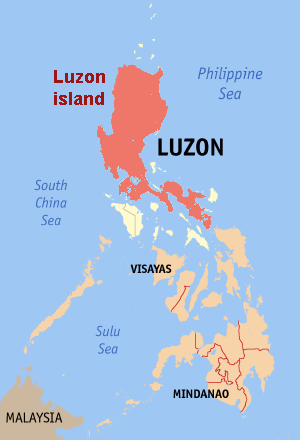
Luzon: It is the largest and economically and politically important island of Philippines. Manila, the capital of Philippines, is located on this island.

Newfoundland: The 16th largest island in the world, Newfoundland lies at the mouth St. Lawrence River, Canada. It was explored by John Cabot in 1497. It is a former colony of United Kingdom. It became the tenth province to the Confederation on 31st March, 1949, named simply as Newfoundland.

Cuba: Cuba, the largest island of Antilles, lies in the Caribbean Sea has a rainy, tropical climate. Sugarcane is the main crop of Cuba which occupies about 60 per cent of the cultivated land. Cubans call themselves 'Afro-Latin-Americans. Population of mixed descent (Mulattos) is 51 per cent, whites 37 per cent and blacks 11 per cent. Spanish is the main language. Havana, the capital and largest city of Cuba, is located on this island.

Iceland: Located between the North Atlantic and the Arctic Ocean, Iceland is an enormous plateau with an average altitude of 500 metres. Reykjavik is the capital and primate city of the country. About 96 per cent of Icelanders are the descendants of Norwegian, Scottish and Irish immigrants and are Protestants by faith.

Mindanao: It is the second largest and easternmost island of Philippines. The island of Mindanao is called The Land of Promise. Mindanao is the only area of Philippines with a significant Muslim population. A guerrilla war is ongoing on this island.

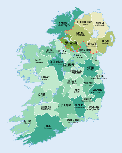
Ireland: An island of the British Isles lying west of Great Britain. Four - fifths of it is occupied by the Irish Republic, and remainder by Northern Ireland. Its economy rely heavily on agriculture, especially beef production and dairy farming, settled by Celts. Most of the people are Christians by faith.